According to a report by European News TV on September 5th, French Foreign Minister Barrot recently announced that the French Ministry of Foreign Affairs will abandon the Mercator projection map in favor of the Eckert IV projection map, which better reflects the actual proportions of each continent. The reason for this change is that the Mercator projection map can be misleading.
Barro spoke at the Sorbonne University, saying that it is time to correct the way people perceive the world through the maps created by 16th-century Western navigators. "Maps have never been completely neutral. Take the Mercator projection, for example—everyone is familiar with this type of projection map from a young age. However, the regions we see on maps do not correspond to their actual sizes."
He gave an example: on a Mercator projection map, Greenland appears to be almost the size of the entire African continent. In reality, Greenland’s area is close to that of the Democratic Republic of the Congo in central Africa.
Barlo emphasizes: "Altering the map will not change the world, but correcting the deviations in the description of the world itself is a pursuit of truth."
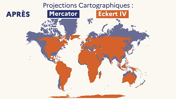
Comparison between Mercator Projection and Ekert IV Projection
According to a diplomatic source quoted by Euronews, France will not immediately change the maps used in diplomatic contexts, but related adjustments are already underway. The report states that the French Ministry of Foreign Affairs has been reducing the use of Mercator projection maps since 2021, aiming to present the world's geographical situation more accurately.
However, French diplomats stated that the Mercator projection map still has some practical value in local regional mapping or traditional maritime navigation, as it can maintain accurate angles.
The Mercator projection was proposed by the cartographer Mercator in 1569. The constant lines are straight, which facilitates navigation, and thus it has long been the default map for textbooks, media, and many digital maps. However, Mercator projection maps cause area distortion, making regions in the Northern Hemisphere appear too large visually, while regions like Africa and those near the equator appear relatively smaller.
On September 4th, local time, the United Nations General Assembly voted to pass a resolution encouraging countries and organizations to reduce the use of Mercator projection world maps in education and public communication settings, and instead use ‘equal Earth projections’ that better reflect the true relative areas of land.
This “amended map” resolution was proposed by the Togo representative of the African Group and received support from the African Union. The resolution was ultimately adopted with 164 votes in favor, 1 vote against, and 6 abstentions. The only opposing vote came from the United States. The resolution is not legally binding, and it does not prohibit the continued use of the Mercator projection in navigation and aviation.